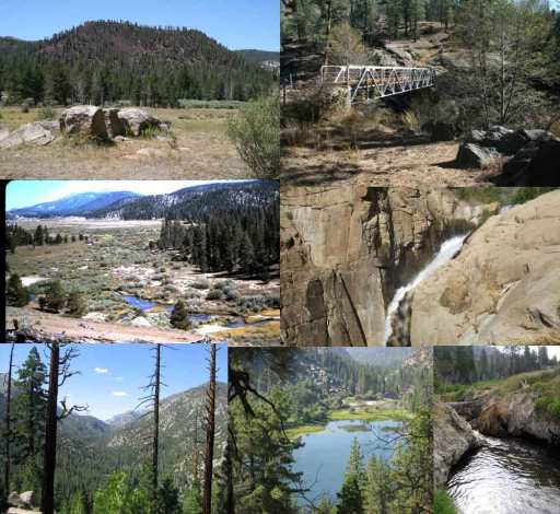
The Eclectic Tour is approximately 60 miles round trip. The trek will take users to what could be considered the center or heart of the Golden Trout Wilderness. Users will see Wild and Scenic rivers, canyons, volcanoes, lava flows, large meadows, cross bridges, check out some hot springs, and more. Essentially users will get to see a little bit of everything the Golden Trout Wilderness has to offer.
The trip starts on the Sequoia National Forest side, but could easily be modified to start on the Inyo National Forest side. To keep the miles and nights the same, starting at the Blackrock Trailhead on the border of the Inyo National Forest and Sequoia National Forest would be a good idea. Just trek down Ninemile Creek on the way out and come back up Ninemile Creek to conclude the trip.
Download Maps
Eclectic Loop Map Part 1 of 8
Eclectic Loop Map Part 2 of 8
Eclectic Loop Map Part 3 of 8
Eclectic Loop Map Part 4 of 8
Eclectic Loop Map Part 5 of 8
Eclectic Loop Map Part 6 of 8
Eclectic Loop Map Part 7 of 8
Eclectic Loop Map Part 8 of 8
Day 1 – Lewis Camp Trailhead to Willow Spring (8.6 miles)
Lewis Camp Trailhead is located near the Golden Trout Pack Station at approximately 7,695 feet elevation. The trail heads downhill for approximately 4.1 and arrives at the Little Kern Bridge. Approximately 1.6 miles down from the trailhead a 4-way trail junction occurs. Left goes to Grey Meadow and right goes to Jerky Meadows Trailhead. Proceed straight and within a mile the trail intersects Jug Spring. Another mile later the main trail goes north (left). Users can continue to go straight but the trail is no longer maintained. Both paths lead to the Little Kern Bridge, so it is up to the user. Sticking with the main path, the trail will intersect a couple of other smaller “cutoffs.” Proceed right at all junctions and the trail will end up at the Little Kern Bridge.
The Little Kern River is a dependable source for water. The next few miles will be void of any water sources until you arrive at Willow Meadow. Plan according, proceed across the bridge, and follow the river for about a half a mile. A trail going uphill (northeast) to the left is where you want to go. Hike uphill for about 1.5 miles to a four-way junction. Proceed straight another 1.5 miles and the trail will junction with the northern portion of Trout Meadow. A “cow camp” is located under some trees to your left just prior to the junction. Continue straight (north) half a mile to Willow Meadow. Just beyond Willow Meadow the trail goes through some trees and arrives at a smaller meadow with developed spring. A small camp is located to the east in the shade. Set up camp here for the night.
Day 2 – Willow Spring to Wilderness Boundary (8.0 miles)
Depending on the time of year, you may want to start as early as you feel comfortable. Temperatures can be quite warm for this next stretch of the trail due to lower elevations. Proceeding north and leaving Willow Meadow spring you’ll be entering into the Kern River Canyon. A nice vista point provides a great view of the lowest unglaciated section of the canyon.. Proceed downhill along the trail and pass by the Hell For Sure trail junction about a mile later.
Now walking along the Kern River Canyon floor, you’ll hear the roaring Kern. Temperatures should be cooler and the trail stays along the western bank. Continue heading north up the canyon for another 5.6 miles. Making your way to the lake, keep your eyes open for a large rocky landslide to the east. When you see the slide, imagine the force and amount of debris it produced to dammed up the Kern River. Just before arriving at the lake, you’ll make a steep, but short climb out of the canyon via Devil’s Staircase. However, the trail drops right back down shortly after your ascent. You’ll arrive at Little Kern Lakes where you’ll soon after need to climb up over a small pass to Kern Lake. From there you’ll trek another couple of miles to the boundary. A trail junction is just a few hundred feet before the boundary. The junction has a sign indicating you are going to enter the Park. Take a right to avoid the park and trek another few hundred yards. A nice dispersed camp with “camp furniture” is next the river. Set up camp and enjoy a stay by the Wild and Scenic Kern River.
Day 3 – Wilderness Boundary to Groundhog Cinder Cone (8.3 miles)
The trail is a gradual climb for about 0.5 miles. You’ll cross the Kern River and will be entering the Inyo National Forest side of the Golden Trout Wilderness. The trail gets steeper starting near the Golden Trout Creek confluence with the Kern River. Climb uphill for another 3 miles. Along the way you will get to see Volcano Falls and walk over natural Bridge. Just past Natural Bridge, the trail becomes less steep and enters into an old lava flow.
A minor trail junction occurs when you arrive at the lower end of Little Whitney Meadow. The trail goes south, but you will want to continue straight ahead and proceed around the northern side of Golden Trout Creek and southern side of Little Whitney Meadow for another 0.4 miles. A trail enters in from the north. Proceed east towards Tunnel Meadow/Ramshaw Meadows. Trek along for another 2.7 miles with views of the Groundhog Cinder Cone across the way. The trail will be on the eastern edge of the lava flow when a trail from the south enters. Take the trail south to set up camp near the creek for the night.
Day 4 – Groundhog Cinder Cone to Redrock Meadow (10.6 miles)
Go back north to the trail junction and make a right (east) to the next junction about 0.6 miles later. The trail cross Golden Trout Creek just prior to the junction. Take a left (north) for another 0.3 miles to the next junction. Five trails enter together at this trail junction. You’ll want to make sure you are heading in a more east/southeast direction towards Ramshaw Meadows/Templeton Meadows. The trail will take you along the northern side of Red Hill in about 0.3 miles. Once at Red hill you will start to get a nice view of the South Fork Kern River flowing through Ramshaw Meadows.
Continue along the trail for another 4.7 miles. Views of Ramshaw Meadows and the surround mountains will be to your left. To the right is Kern Peak and the Toowa Range. The trail climbs up a small pass and drops into Templeton Meadows about a mile before a trail junction. At this 4-way trail junction, a left goes back north to Trail Pass. Continuing straight will take you towards Strawberry Meadow and along the south side of Templeton Mountain. A right will take you across a creek and uphill to Templeton Cow Camp. This is the direction you want to go (south).
The trail climbs gradually uphill for about a mile to Templeton Cow Camp. At the trail junction, take a right (west) and continue hiking an additional 2.1 miles uphill to a pass between the Toowa Range. Once at the pass the trial drops downhill towards Redrock meadows for approximately 2.6 miles. Once at Redrock Meadows find a spot to set up camp.
Day 5 – Redrock Meadow to Kern Flat (11.6 miles)
Assuming you established camp before the trail junctions within Redrock Meadows, continue south down the trail and make a right (northwest) at the first trail junction. Shortly after the trail crosses a creek and another trail junction occurs. Take a left (west) and proceed to contour around the western edge of the meadows towards Indian Head rock. The trail goes through a small saddle and the rock will be to the south on a ridge point. The trial now continues downhill for another 4.5 miles to Jordan Hot Springs. The trail also follows Redrock Creek, so water should not be an issue.
After completing the 4.5 mile trek downhill, proceed to the right at the next trail junction. Jordan Hot Springs will on your left and the cow camp is across Ninemile Creek. You may be able to see some cabins to the south too. Check out the history section of the site to learn more about this historical place.
The trail continues west and follows Ninemile Creek drainage. About 2.7 miles later a trail enters in from the north. Continue straight ahead and around another knob on a ridge to the next trail junction about 1.3 miles later. Along the way to the next junction the trail will begin to descend down to Soda Flat. A private cabin is located on the west side of the trail in Soda Flat. Keep left at the next three trail junctions and the trail will head south along the eastern side of the Kern River.
About 2.2 miles of trekking along the Kern River, the Kern River bridge will be on your right. Follow the trail across the bridge and make a left (south). Hike another mile and you will arrive at Kern Flat. Set up camp here for the day and, if you have a pole, enjoy some fishing along the Kern River.
Day 6 – Kern Flat to Little Kern River (8.9 miles)
If needed, you may want to start early and stretch a bit. There is no “warm up” for the next few miles as the trail climbs up to Trout Meadows. Make sure to drink plenty of water and bring full canisters as water for the next 6 miles may be hard to come by.
Starting off at the trail junction in Kern Flat, proceed to the west and uphill. About 3 miles of uphill climbing will bring you to the Flatiron. The Flatiron is an old lava flow and is properly named. During late summer months the area can become excessively hot. Another 3 miles and the trail joins in with another trail just above Trout Meadows. Take a left (south) and you’ll enter Trout Meadows in about 0.2 miles.
Trout Meadows guard station will be on the right. A spring that flows all year is located here. If you need some water, grab some before proceeding. Otherwise it is another 2.7 miles to the Little Kern River. A small picnic area in the shade is located by the guard station for users to enjoy.
Continuing down the for another 0.5 miles. The trail will begin to turn to the right (west) and start trekking down to the Little Kern River. About 2.2 miles later the trail comes to the Little Kern River. You can set up camp in a couple of places along the river. The Little Kern River bridge is also located here. Enjoy fishing and resting for the 4.1 miles of hiking uphill tomorrow.
Day 7 – Little Kern River to Lewis Camp Trailhead (4.1 miles)
Again, depending on the time of year, start early so it isn’t as hot. There isn’t a really dependable water source other than Jug Spring. Sometimes if flows so slow though so it is recommended you hydrate well the night before and in the morning.
Begin by crossing over the Little Kern Bridge. Once across the trail goes to the right and begins climbing uphill. If you chose this way on day 1, just walk back exactly the way you came and you’ll arrive at the Lewis Camp trailhead concluding the trip.


